It has been a while since I have posted but that is because I was hiking 240 miles through the most amazing place in California, the Sierra Nevada. I can't put in every detail of what it was like but I will try my best to summarize the last two weeks or so.
My last post was written in Kennedy Meadows (Mile 702) and it is considered as the last stop before the Sierra for the people who are hiking on the PCT. To tell the truth though, the real Sierra don't start for another 50 miles or so after Kennedy Meadows, and these 50 miles are part mountain, part desert, but totally better than any of the previous 702 miles. What I mean is that you are in the mountains because it is cooler (the first night out here was actually cold enough that I could sleep in my sleeping bag for the first time in a few days because during the desert, I would overheat in my bag and not sleep well), there are pine trees, and the look reminds you of the the mountains, but there are still cactus and the water sources are still 15 to 20 miles apart (tell tale signs of the desert). Don't get me wrong though because this strange mash-up was exactly the moral boost I needed.
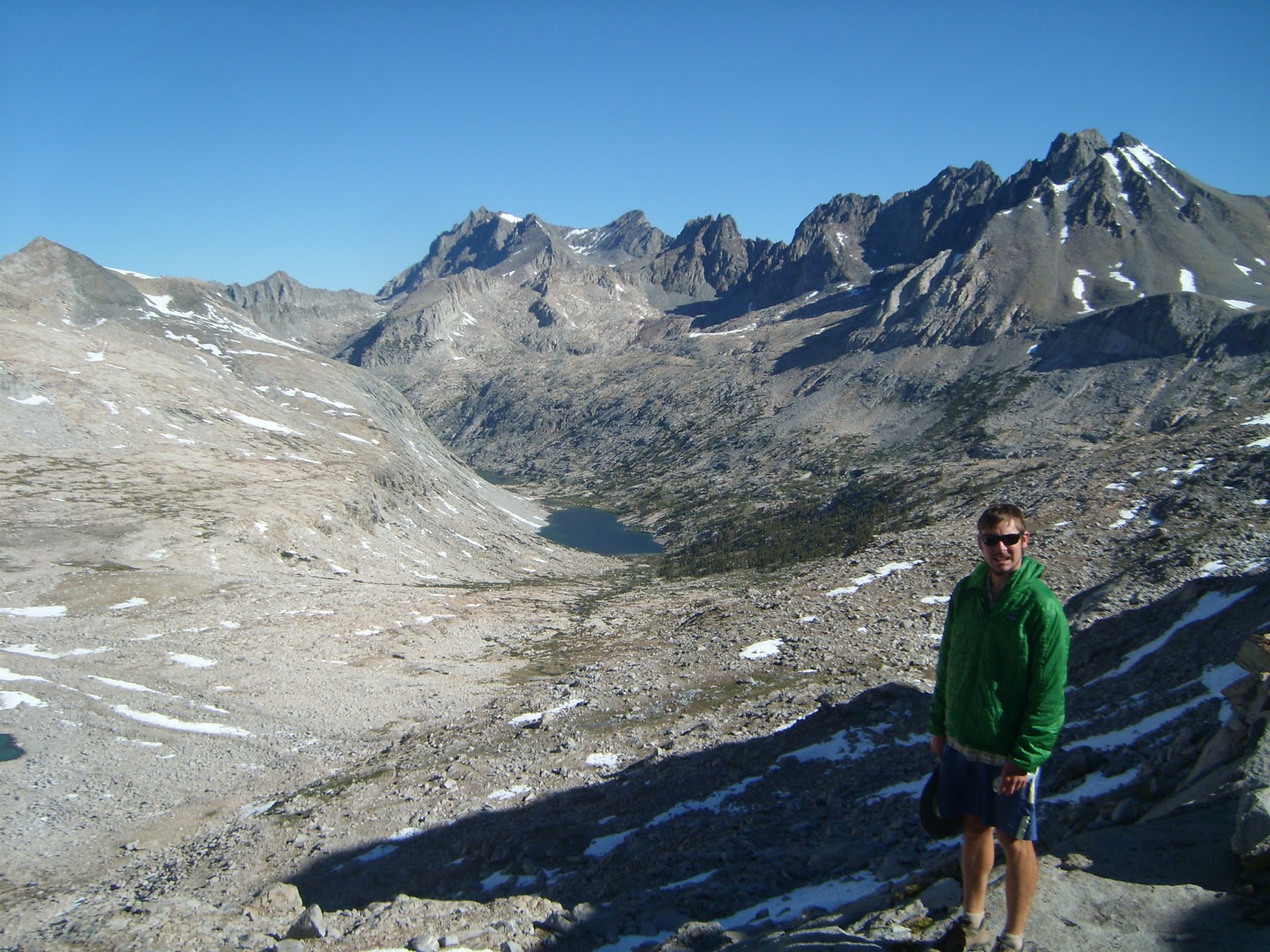
After this awkward 50 mile stretch, you finally feel like you are truly in the mountains: water is freely flowing, you can see snow on far away peaks, the nights are cold, and the mountains look rugged. The sad thing was that I hadn't seen any meadows though. For me, meadows are the thing that makes me feel like I am in the Sierra. but about 8 miles south of the Mt. Whitney trail turnoff, I came by, what came to be, my favorite meadow. It was called Rock Creek and it had everything I think of a meadow, lush, green, lots of water, and it was just beautiful. Of course I took a break there, but had to move on because I needed to get close to the Whitney side trail because I was going to climb it the next day.
Of the highlights of the Sierra, summitting Mt. Whitney is one of them. You start in a place called Crabtree Meadows, hike 8 miles east on a side trail that is not part of the PCT, ascend about 6000 feet, and end at the summit. The highlight of the trip, besides the summit, is that you don't have to drag your whole backpack up. Because this is a side trip, I ditched everything except for some food, water, and my down jacket in a bear box and hiked to the top like a day hiker. It was great to not have to carry all of my stuff and have a backpack that weighed under 10 pounds! I wanted to make it up there for the sunrise, but I was to tired to wake up at midnight or 1 am to make it to the summit in time (Also, it would have been in the high 30s or low 40s). Instead, I got up at 430ish to get an early start on the day. The hike to the top was hard, but easier than going up from the Portal side (for those who have done that hike). Once at the top, it was interesting to see how little snow that the Sierra had.
This past winter was a low snow year and it is so low that there was very little snow anywhere (A ranger told me the Sierra look as they do in August or September). The last time I climbed Whitney was over the 4th of July in 2011 and that was a high snow year. That climb required crampons and ice axes but that equipment was overkill for this year. I did come across random snow patches later in my trip on some of the passes but nothing remotely dangerous or difficult.
After Whitney, the Sierra passes start and I reached Forrester Pass (highest point on the PCT) the next day and then left the Sierra to resupply at Independence (Mile 800ish), a small town on Highway 395. After 24 hours and one of the best carne asada burritos ever, I hit the trail again and had the best 4 days of the trip so far. These days were great because you were truly in the middle of nowhere. You climb a pass a day and then go into a great valley/meadow, but the views were the best of the whole Sierra. After climbing Kearsage Pass (to go to Independence), Glenn Pass (the most mentally difficult one), Pinochet Pass (the one where I felt like I hiked uphill all afternoon to get there), and Muir Pass (the one with the most snow and probably the most difficult), you are done with the most difficult passes and start to go in to the lower Sierra. Then you have two more passes, Seldon Pass (this one was super hot) and Silver Pass (the easiest) and then you are in Mammoth!
I got to Mammoth on Sunday (6/23), went into town for a quick resupply, and then headed back out to the trail on Monday (6/24). Because I am meeting my sister and her family in Mammoth later in the week, I decided to hike the 36 miles from Mammoth (Mile 906) to Toulumne Meadows (Mile 942) really slow, enjoy the beginning of the end of the Sierra, and then circle back to Mammoth once I got to Toulumne. The weather decided to be difficult though, and I ended up hiking in the rain all day Monday and part of Tuesday. This mean that instead of enjoying these 36 miles, I went full speed ahead to get back to Mammoth and out of the weather. It was the worse weather I have had yet and everything was just slightly soggy, so getting back to Mammoth to dry out and relax was what I needed.
I will be off trail in civilization for the next few and then it back to my job of hiking.
I will post pictures tomorrow once I have a chance to go through them!