This is my last post about my PCT trip. Some final thoughts, stats, and closing about the last 5 months. Also as a note to all who read this, I am looking for job as you read this, so if you or anyone you know are interested in hiring me, please send me a message through the blog!
As anyone who has read my blog knows, I left my job in mid-April to try to hike 2660.1 miles from the border of Mexico and the US to Canada. To get there, I hiked through the desert, Southern California mountains, the Sierra Nevada, near Lake Tahoe, through northern California (which was a cross between the desert and mountains), the Cascades, Oregon, Washington, and then finally the northern Cascades. As I hiked through Washington, the beginning and middle of my trip seemed so far away. Almost like it was another trip because the conditions changed so much. No longer was I carrying 5-7 liters of water with 5-7 days of food in exposed and hot desert, but I was carrying 1-2 liters of water with 3-4 days of food.
It's amazing to think where I've been, who I've met, and how I have handled so many diverse and different environments and people. One of the cool things of the PCT is that you never know where people you have met on the trail are. One of the people I met on my first day and saw around mile 600, showed up again around mile 1900. I was normally the one who seemed to "skip" around on the trail and because of this, I got to see many of the slower hikers again.
I started the trail on May 1st and thought that I could make it. After just eight days on trail though, I couldn't continue because of two feet full of blistered. I learned quickly that the PCT was all about taking care of yourself: making sure you eat enough and balanced, making sure you don't hike to much in one day, making sure you get enough rest, making sure you are emotional well, making sure your body is prepared for the next day. This was the challenge of the trip that manifested itself all the time. For someone like me who did much of their hiking alone, making sure I hiked or camped with others was as important as getting the nutrition and calories I needed everyday.
While I sat at home contemplating my blisters and my choices that led me to not being about to walk, I wondered if I would finish the PCT. 2660 miles is a lot but breaking it up into 100 mile chunks made it much easier. After 5 days of R and R, my feet were ready to hike and I got back on trail. My blisters and feet issues never completely stopped until I made it into the Sierra Nevada (~mile 800). It did slowly get better but I wasn't able to hike without moleskin until then.
I soon found out that the Southern California section of my trip was "my tour of friends and family" because I stayed with them almost exclusively throughout my town stops in SoCal. It was a nice way to still feel connected to my pre-PCT life and help others experience the PCT.
It's funny to think about how challenging SoCal was in the first 6 weeks (blisters, heat, lack of water, skipping a section of trial) but the Sierra Nevada really made SoCal seem like a mental challenge because it was such a physical challenge. After 2 weeks of climbing mountain passes, summitting Mt. Whitney, and living at 8000 to 13000 feet, my body was adjusted to the rigors of this hike. The Sierra Nevada made the hiking afterwards easy because the hills were smaller, I was fitter, and I could crank out miles.
This continued until a my shin splints/tendonitis in Etna, Ca where I went home for 10 days. This was the first time since my blisters that I seriously wondered what was to happen to my trek. I had seen the spectacular Sierra Nevada, survived the desert, and had almost gotten through the (mostly) boring Northern California when my right upper ankle/lower shin hurt. I knew I couldn't continue and needed rest, but the question was for how long.
After some much needed R and R (I had spent much of the prior 10 days hiking high 20 mile or low 30 mile days), I got back on trail and made it to Oregon, the third big morale boaster (number one being making it to the Sierra Nevada and number two being making it to Lake Tahoe (ie out of the high Sierra)).
Oregon proved to be flat, a green tunnel, mentally taxing, and harder than I thought. It was great to see Crater Lake and the big volcanic Cascade mountains, but the weather made it difficult. After a storm near the Three Sisters Wilderness, I had my only moment when I really wanted to quit and would of if I could have. An unplanned stop in Sisters, Or fixed that and I was ready the wetness and weather of the Pacific Northwest. While I wasn't very excited for any type of precipitation, I found it was the wet plants which would soak my shoes and feet that was my problem in the Pacific Northwest.
I got through Oregon without much more issue and got to Washington right before another huge storm hit. I took off an extra off-trail day, and then began the final push for the Canadian border. Because I had never hiked in Washington, I was super excited to be there; however, the first half was very similar to Oregon and boring. Once I got the Snoqualimie Pass and the northern Cascades, the trail became a lot more fun again. This trip culminated with a small storm, cold, snow, and barely beating a big storm. I promised myself that if it snowed on me in Washington that this would end my trip. While I did get snowed on or hiked in snow 3 out of my last 4 days, I would say that I ended right one time.
I hope everyone enjoyed reading about my adventures and looking at just a few of the over 1000 pictures I took while on the PCT. It has been one of the best 5 months of my life but also one of the toughest. Similar to my time living abroad, my PCT trip has changed me and it will take a little time getting use to the "other" world (that is what we hikers refer to the non-hiking world). I look forward to sleeping inside on a bed and not having to wear my same sweating shirt for days at a time between washing but will miss the amazing mountain water I drank and the simplicity of my life. Who know where life will take me next, but it will be fun to see.
Random Stats from my trip:
Top Three Trail Towns: Stehekin, WA; Etna, CA; Mammoth Lakes, CA
Top Three Places on the PCT: Goat Rocks Wilderness, WA; just south of Sonora Pass, CA; the High
High Sierra Nevada (aka the John Muir Trail)
Number of Books Read: 7 completed and 3 partially read (I'm still working on these)
Number of showers taken: 31 (that's 1 shower for every 4.2 days)
Total Number of PCT Miles Hiked: 2526.7
Total Number of "Other" Miles Hiked (to/from towns, springs, etc): 134.1
Total Number of Miles Hiked: 2392.6
Total Days on Trail: 130
Average Miles per Day: 19.4
Most Miles Done in a Day: 35.9
Least Miles Done in a Day: 4.5
Total Number of Nights Slept - Under the stars: 47
In tent without rain fly: 35
In tent with rain fly: 21
In a bed: 27
Inside: 26
Total Number of Days with - Rain: 23
Thunder: 11
Lightning: 5
Hail: 2
Snow: 2
Number of Zero Days: 11
Number of Days taken off trail for blisters, injury, or side trips to see family: 20
SHR Emblem

Sunday, October 6, 2013
Monday, September 30, 2013
Washington Adventures
Everyone must know by now that I have made it to the border and am no longer on the PCT. It's a good thing because I heard that the people on the PCT are getting snowstorms, cold, and winter now. I'm going to use this post to tell about my time in Washington and then post my final thoughts about the PCT later in the week.
Washington started with drama. I was staying with a friend's sister near the Washington/Oregon border and the forecast for the day I wanted to leave was rain, thunder and lightning for the next two days. This meant that I could either face the not so fun elements or stay where I was for another day.
I chose to stay where I was another night and get on the trail the next day. It was a good decision because it poured buckets in the evening and overnight and lightning and thunder was seen/heard also.
While I was able to stay dry for at least one day, I did need to get back on the trail so returned to the PCT on Sep 6th. It was really had because it was a typical Washington day, light rain all day; however, the next 8 days after turned out to be pure bliss. The weather went from crazy rainy (I was told that the storm I experienced in the beginning of September was more rain than the area had received in the month of September for the last 2 or 3 years combined) to clear and hot. The next day after the storm was perfect hiking weather and this continued for about a week.
After the Oregon border, my next stop was a place called White Pass and the 150 trail miles between these places was for the most part good. I got to hike through some amazing old growth forest in the beginning and the rain, while I wasn't excited about it, fit right in. It was amazing to look at the trees, moss, and mushrooms. One of the coolest things of Oregon and Washington was the crazy looking mushrooms I saw. They ranged from tiny to extra large dinner plate size and the colors were amazing. The were really all colors of the rainbow.
Beside the old growth forest, this section wasn't to memorable (it was very much like a "green tunnel") until the end when I went through the Goat Rocks Wilderness. Goat Rocks is so cool because you walk on high ridge lines where each side drops down at least 500 vertical feet to a small valley below. The ridges and mountains were just beautiful and reminded me of the Sonora Pass area near Bridgeport, CA. My only problem with this area was that the wind howled as I went through it. It was pretty strong and it made me nervous on some of the more sketchy areas that I had to hike through (A short section of trail here was the second place on trail that I was actually afraid I might get hurt because of some snow, a steep drop, and the wind). Goat Rocks was right before White Pass, so I ended this section well.
At White Pass, I met one of my sister's and we took a day to drive to and see Mt. Rainer National Park. It was a nice day off and really neat to see the park. Mt. Rainer is so massive and majestic it was just fantastic. This worked out well because when I got on trail the next day (Sep 11th) and walked in the shadow of Rainer, I could never see it.
The next section took me from White Pass and near Mt. Rainer into central Washington where I resupplied at Snoqualmie Pass. This section started in the shadow of Rainer but the real highlight was the huckleberries that I found. I think I have mentioned the huckleberries before but all through Oregon and the first half of Washington, there are tons of these bushes on the side of the trail and this section had the biggest and sweetest berries. Other than that this 100 miles wasn't to exciting. It was a green tunnel more or less so I couldn't get any good views but that all stopped north of Snoqualmie Pass.
A short stop in Snoqualmie Pass included some really good curry, a stay at a really good hostel, and a really good time overall. It had been the first time I had hung out with fellow hiker off trail for a few weeks.
For the next 100 miles, Snoqualmie Pass to Skykomish, the scenery changed dramatically. Everyone told kept telling me that the Northern Cascades were really beautiful and I found this true after I got north of Snoqualmie Pass. The mountain became very rugged and almost Sierra Nevada looking and this lasted for the rest of the trip. Nothing memorable happened during these miles except some rain (which puts me in a little of a bad mood when I can't dry my stuff out) and great scenery.
At Skykomish, I stayed with some trail angels for the night and got out the next day because of the weather forcast was going to be good for the next few days. This meant that I could get to my last stop, Stehekin, without any rain. To do this, I had to hike 3 days that averaged 30 miles but it was worth not having to be in the rain.
I got to Stehekin on Saturday Sep 21st and it was by far one of the best town stops. It is on Lake Chelan, in the Northern Cascades National Park. and you can only get there via boat, hiking, or plane. The reason it is so cool is because it feels like you are traveled back to the 50's or 60's. Only 80 year round residents live there but it seems to have a mainly old trucks. Their is a fantastic bakery there also and that was the best part. I ate cinnamon rolls, sticky buns, scones, savory pastries, and danishes over the day and a half that I was in Stehekin. It was heaven but I had to leave because I only had 90 miles of trail left.
After getting my packages from the Post Office on Monday morning, I got back on trail for the last time, but it now felt like winter. Ever since Snoquolamie Pass, the weather got colder and colder and felt more winter like, but it really felt like winter after Stehekin. My last 4 days on trail were great. I had good company, the scenery was really beautiful, and I got to do a little hiking in snow. The last section is mainly between 5000 and 7000 feet and everything from 5500 feet and up had snow. This meant that going over passes and walking along ridge lines was now done in snow. It all culminated on my last night where it snowed for part of the night.
On Sep 26th, I woke up to snow on the ground and 15 miles until the Canadian border. I climbed once more through snowy passes and made it to the boarder at 12:10. I celebrated with champagne and rice crispy treats that I my sister sent me in Stehekin. There were about 6 other hikers at the border with me and we toasted and celebrated the end of our journey.
I did have to walk 9 more miles into Canada to get to the Manning Park Lodge, where I stayed once I got to Canada, but it was a breeze after 5 months of walking.
 |
| To bad I can't take it with me. |
 |
| That's right. I got to ride a moped on my trip. The best part was the kiddie backpack I used also. |
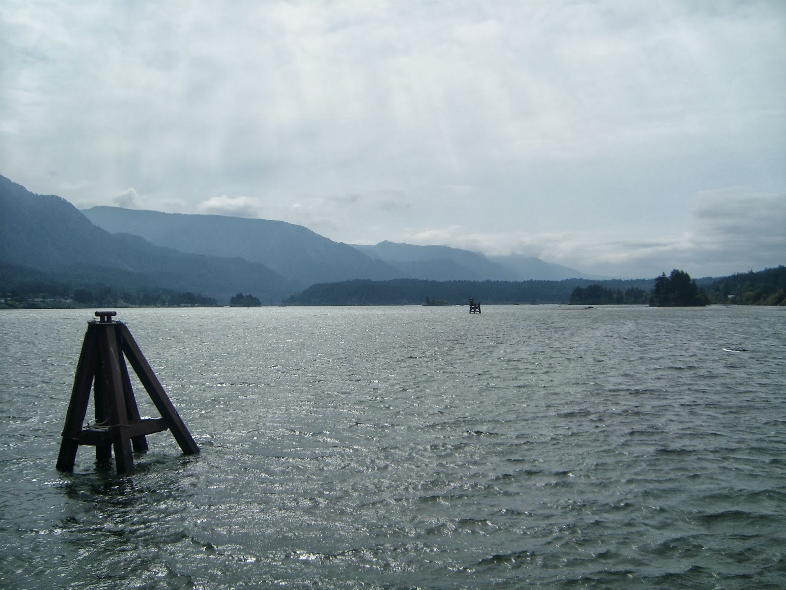 |
| Columbia River Gorge |
 |
| Add caption |
 |
| Mt. Adams |
 |
| Mt. Rainer from afar |
 |
| Goat Rocks and Mt. Rainer |
 |
| Goat Rocks (the trail is on the bottom left) |
 |
| Goat Rocks and Mt. Rainer. Can you find the trail. |
 |
| Mt. Rainer |
 |
| Nice lake picture |
 |
| North of Snoqualmie Pass |
 |
| North of Snoqualmie Pass |
 |
| North of Snoqualmie Pass |
 |
| North of Snoqualmie Pass |
 |
| Had to ford because the bridge is gone |
 |
| Stones to cross a stream |
 |
| At the trail angels near Skykomish |
 |
| A look inside |
 |
| Northern Cascades |
 |
| Meadow |
 |
| Glacier Peak |
 |
| Hunting yurt in the mountains |
 |
| Glacier Peak |
 |
| After a night of snow |
 |
| On the last morning |
 |
| You can see how much snow I got on my last night. |
 |
| Finally! |
 |
| At last! |
 |
| So excited! |
 |
| Putting back together the place where the trail register is. |
Thursday, September 26, 2013
9/26/13 FINISHED
Exciting news...Daniel crossed the border into Canada today at 12:10pm. Thus, completing the Pacific Crest Trail. Hooray!!!
He reports that he finished just in time as the last 2 days had snow. Today when hiking his water bottle turned slushy. Fellow PCT hiker friends were with him at the border, they celebrated with champagne. He is off to see the sights of Vancouver, BC on Saturday.
He reports that he finished just in time as the last 2 days had snow. Today when hiking his water bottle turned slushy. Fellow PCT hiker friends were with him at the border, they celebrated with champagne. He is off to see the sights of Vancouver, BC on Saturday.
Sunday, September 22, 2013
4 HIKING MORE DAYS!!!!
I've made it to the great town of Stehekin, Washington. It is just a fantastic small town that you can only access via boat, plane, or hiking. That's right...you can't drive here.
I'm waiting for the Post Office to open and then will be off for my last 4 days or hiking. I'm hoping to be at the northern terminus of the PCT (aka the Canadian boarder) on Thursday mid-afternoon and then will walk the last 9 miles into Canada on Friday.
Here's to the last few days!
-Dan
I'm waiting for the Post Office to open and then will be off for my last 4 days or hiking. I'm hoping to be at the northern terminus of the PCT (aka the Canadian boarder) on Thursday mid-afternoon and then will walk the last 9 miles into Canada on Friday.
Here's to the last few days!
-Dan
Tuesday, September 17, 2013
almost there
Daniel made it to White Pass 9/12/13. He had much fun picking huckleberries and salmon berries along the way. Today he is expected in Skykomish, WA
Karyn (dan's sister)
Karyn (dan's sister)
Wednesday, September 4, 2013
Finishing off Oregon! That's right, I have one more state left.
It has been a week since I left Sisters, OR and the it also was the last 7 days that I would spend in Oregon on the PCT. I spent about 24 hours in Sisters, enjoyed eating at their bakery (I went 3 times while I was there), walking around their little downtown, and getting some great fruit from a random fruit stand in town. Essentially, it was the break I needed to give me the energy and resolve to finish my trek.
Once I got back to the PCT at a place called Santiam Pass, I had about a week to go until I crossed the Washington/Oregon boarder. After this pass, you go around a mountain called 3-Finger Jack. It is really rugged on top and you get views to the east and south as you hike around it. I was able to see the Sisters (a series of 3 mountains that I went by about 4 days earlier) and the other peaks and buttes around.
After getting around 3-Fingered Jack, you get near Mt. Jefferson, one of the volcanic Cascade mountains, and in the two days that I went around this mountain, there were tons of wild huckleberry bushes. For those who aren't familiar with Oregon, huckleberries are a local delicacy that people flock up to the higher elevations in the mountains to gather. They look similar to a blueberry but are more of a black or really dark blue color. Everyone who know how much I love fruit, and especially berries, knows that I was in heaven. One morning I had a lot of trouble hiking because I was stopping to eat berries about every 10 minutes. I was glad I did because these two days were the best for them.
After Mt. Jefferson, you come out of the wilderness and go by some lakes and places that are more accessible to day trippers and weekend warriors. Because it was Labor Day weekend, I began to see a lot more non-PCT people about hiking, being on the lakes, picking huckleberries, and just taking advantage of their long weekend.
I then went around Mt. Hood which was pretty cool also. All of the Cascade mountains have been neat to see but I think, Mt. Hood has been the biggest and most dramatic so far. This could be because I hiked through a lot of gullies and got to see the mountain from these perspectives which make it seem huge and me really small.
On Mt. Hood is the Timberline Ski Lodge (and yes people were still skiing when I was there) and a fantastic breakfast buffet. Along with about 7 other hikers, I sat at this buffet on Sunday morning for about 3 hours as I ate as much breakfast as I could hold. Eggs. Pancakes. Belgium waffles. All types of fruit and pastries. Sausage. It was heaven!
After I got done the the buffet and around Mt. Hood, I near the Washington/Oregon border and took an alternate route to get there. I took the Eagle Creek trail and this is one of the highlights of my trip. It goes by at least half a dozen waterfalls, and you actually go through one because they blasted a hole in the rock so you could do this, and it is just really beautiful. It was a perfect way to end Oregon and walking on the Bridge of the Gods into Washington and over the Columbia River Gorge was the perfect was to start that state.
Right now, I'm enjoying a day off at a friend's sister's house who lives near the Oregon/Washington border and will taking off again tomorrow or on Friday. The weather will decide because it is suppose to rain tomorrow so I may just wait another day so I won't have to be stuck in it.
 |
| I just love small towns. Sisters, OR wanted you to use these little flags when crossing the street. Random but homey. |
 |
| For some reason random zucchinis are following me on the trail. |
 |
| Me with Washington and the Sisters...mountains that is. |
 |
| 3-Fingered Jack |
 |
| Mt. Jefferson |
 |
| The white at the top of the picture is not a mistake. It is what the tops of the Cascades look like a lot of the time. Hidden in the clouds. |
 |
| Don't know if the mushrooms had anything to do with the rehab. |
 |
| Mt Jefferson and Ollalie Lake |
 |
| Random chair |
 |
| The best PCT trail marker I have seen |
 |
| There was a spring that came from a spruce tree. Must I say more. |
 |
| Mt Hood |
 |
| After my breakfast buffet with Mt. Jefferson barely viable in the background |
 |
| 550 short miles left |
 |
| Mt Hood again |
 |
| Tunnel Falls. |
 |
| Wait. Am I in the right spot. The PCT wants me to walk on an actual paved road and under a freeway. |
 |
| Almost to Washington |
 |
| Bridge of the Gods |
 |
| Columbia River Gorge |
 |
| What does this mean. Do I collect $200 also? |
Subscribe to:
Comments (Atom)